
So you have decided you are going to investigate the Pacific Crest Trail or PCT for short.
You are interested in section hiking or maybe thru-hiking the entire trail but need to learn more about it before you feel good making a decision.
Well, you are in luck as that is the reason I have compiled all this information below as I am trying to plan the same trip!
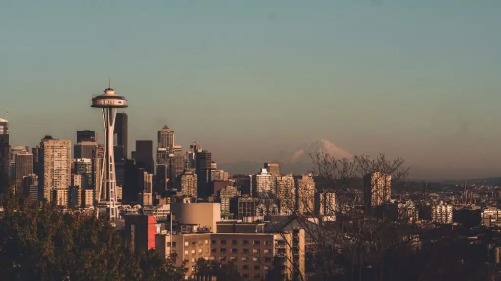
What Is The Pacific Crest Trail (PCT)? The PCT is an amazing 2000+ mile trail that runs from Mexico to Canada through some of the most beautiful wilderness and alpine areas in the continental United States. It is only three states in total length but will be one of the most interesting and diverse areas outdoors you will ever encounter!
Let’s dig in and start covering the main or primary concerns you will more than likely start researching. Then we will move into some more in-depth information to help guide you along your path to starting your thru-hike or section hike.
Basics Details of the Pacific Crest Trail
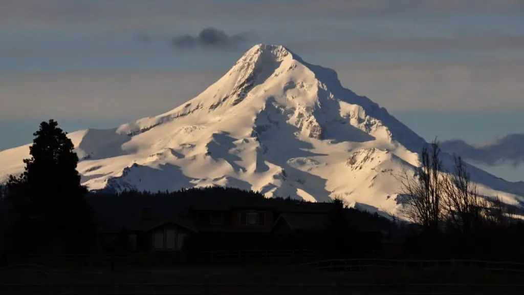
There aren’t many trails that can drastically change and go through as many different climates as the PCT manages to do on a fairly consistent basis. It starts in a desert with temperatures that can get to 110 °F then up into the Alpine areas in the Sierras which can drop to 0 °F.
The Pacific Crest Trail requires a vast skill-set and the ability to change out gear by knowing the trail ahead before you have even seen it. Many will accomplish this by sending themselves resupply packages and bouncing them forward if not required, an awesome list of points here.
The Pacific Crest Trail climbs through nearly 60 major mountain passes while it also descends into 19 major canyons. The beautiful trails pass more than 1,000 lakes and tarns, 3 national monuments, 7 national parks, 24 national forests, and travels through 33 federally mandated wildernesses.
https://www.mspct.com/pct-facts/
What is the Route of the Pacific Crest Trail?
The Pacific Crest Trail is an amazingly long and beautiful 2,650 miles long. The southern terminus starts in Campo, which is a small town right on the United States and Mexico border.
When you search online you may find some other distances listed for the PCT but the Pacific Crest Trail Association believes that 2,650 miles is the most accurate measure.
PCTA
The trail then continues through California, Oregon, and Washington before reaching its northern terminus at the United States and Canada border at Manning Park, British Columbia.
The PCT is split out into 30 sections which are broken out into the following:
- 18 Sections Within California
- 7 Sections Within Oregon
- 5 Sections Within Washington
Each section is a different length depending on the location and the terminus points available. If you are to average the trail out over 30 sections you get an overall length of each section at around 91 miles.
How Long Is The Trail In California
The overall trail length in California clocks in at around 1700 miles. If you are managing to hike 20 miles per day then the required days to complete the California section of your thru-hike will come in around 85 days.
California has a lot of elevation change also within the 1700 miles. Over the 1700 miles, you will gain an overall elevation gain of 192,339 feet!
How Long Is The Trail In Oregon
The overall trail length in Oregon is much shorter at around 457 miles. If you are managing to hike 20 miles per day then the required days to complete the Oregon section of your thru-hike will come in around just short of a month at 23 days.
Oregon has a decent level of elevation change also within the 457 miles. Over the 457 miles, you will gain an overall elevation gain of 49,647 feet!
How Long Is The Trail In Washington
The trail gets a little longer in Washington coming in at around 500 miles. If you are managing to hike 20 miles per day then the required days to complete the Washington section of your thru-hike will come in around just short of a month also with 25 days.
Washington has some solid fitness work as it has a large level of elevation change within the 500 miles of trails. Over the 500 miles, you will gain an overall elevation gain of 72,725 feet!
Best Times To Hike The PCT
This is frequently discussed as to which way is more difficult and that maybe the travel should be more balanced as the trails are frequently beat by large crowds hiking together north bound.
Either choice you make requires some understanding of the prime time to start the thru-hike to ensure completion successfully with minimal weather related issues.
NOBO or North Bound
By far, around 85-90%, of thru-hikers hike the Pacific Crest Trail in this direction. This way is logistically more straight forward and hits the desert and other areas where it can be timed for better or more favorable weather and heat.
You may wonder what is meant by the best time to hike the trail and why it would be different when traveling northbound or southbound. What is interesting is how weather can impact each of these journeys and why it needs to be taken into consideration when you plan to start your PCT hike.
Most NOBO travel has to take into account the time required for the trip as you are trying to get through all the mountain passes before any significant snowfall should occur.
You should start in late April if you’re going northbound. This ensures you are traveling in the desert at a more controlled temperature and that you should hit the Sierras while snow is melting and becoming easier to make it through the passes.
SOBO or South Bound
This hike requires better time management and typically experience overall as you will be trying to hit the mountains as snow is melting but before the winter starts in again at the Sierras.
This means running a smooth trip and staying to your timeline without having too many zeros or you may run into issues with fresh snowfall.
You should start in late June if you’re going southbound. This time is after most of the snowfall in Washington has melted or melted as much as it will for the season giving you the best ability to make travel.
Another issue with southbound travel centers around entering the United States. If you enter along the PCT it is considered a federal crime as it is “entering the U.S. without passing inspection”.
There is no legal way to do this method without taking chances of being arrested.
Though some choose to do it anyway as they know that the US being able to enforce this law out in the backcountry. The other method is that you choose instead to start at Hart’s Pass. Once there then you head north to the border, touch Monument 78, then turn around and hike south to Mexico.
Time To Complete A PCT Thru-Hike
A huge consideration that will take up your initial efforts is getting a grasp on the sheer amount of time a thru-hike of this distance will take. It is a serious commitment where you will need to be very difficult to reach for upwards of 4-6 months!
Due to the differing climates, you will need to also take into considerations that if you fall too far behind your pace you may reach someplace which is actually impassable due to weather conditions. This could mean having to bail on completing your thru-hike before you would want to quit.
Most hikers will accomplish somewhere in the area of 10-20 miles each day while hiking. This number will vary though according to conditions as growing up in Washington when you are post-holing in snow you are grinding distance and a 5-mile day may be all you can do to sheer exhaustion.
You will also take plenty of NERO or ZERO days where you get into town to wash clothes, clean up, get some good food and restock.
These days will add up over time and can leave you high and in the snow at the wrong time of the year, mountains start in California and continue all the way to the Canadian border.
If you are experienced in long-distance hiking and have good “trail legs” you may be able to manage a much larger amount of mileage each day.
The experience if not taking in the sites and sounds, has been able to finish long 2000 mile plus hikes in under 100 days.
Though this is normally when they are on the trail for a second time as this gives them the experience to know where they can make it to and where they want to stay on ZEROs.
Are Any Permits Required For The PCT?
There are three required permits for the Pacific Crest Trail travel. All of these are free and easy to obtain as long as you prepare properly and don’t forget.
- Planning To Hike Over 500 Continuous Miles – You will need a thru-hiking permit.
- Which the official permit information page includes everything you need to know about permits as well as a link to the application.
- NOBO Thru-Hikers – You will need a permit to enter Canada.
- Note that it is illegal to enter the U.S. from Canada (though there is no one there to stop you).
- California Fire Permit For Camp Stove Use – If you plan on cooking food or even boiling water in California you will need a California Fire Permit.
- One simple and quick quiz will get you a permit and print it at this website.
- No matter if you have a permit, campfires are not allowed anywhere in Southern California or areas facing dangerous fire conditions.
Is Prior Experience Is Required?
It is recommended but not a requirement. Many start a thru-hike without prior experience in long-distance hiking, this will make it more challenging for you though in most cases. You are learning on the trail which should help you later as you get further into your PCT hike.
Maps And Guidebook Resources
The PCTA site has some quality maps and guidebooks and is an excellent resource. You can also find PCT books and maps at many gear stores around the country, or on Amazon.
Equipment For The Pacific Crest Trail
Each hike will require some prior time to properly figure out the correct gear for a successful completion. This is no different on the PCT which changes elevation, temperature and weather non-stop, forcing you to be on your toes and evaluating changes consistently.
Will I Need Ice Gear To Hike?
While not required for very long stretches within California you will need to pick up some ice gear more than likely around Kennedy Meadows. This should include an Ice Axe (Like This Camp Corsa), snow spikes or crampons, trekking pole snow basket attachment and if really snowy plausibly snowshoes.
After the Sierras you will likely be able to drop most of this equipment and shave that weight back off your pack. For the snow and ice though it is very important to not only have this equipment but know how to properly use them.
What Options Are Good For A Sleeping System?
This depends on your willingness to trade out gear or available funds to purchase different gear. Many hikers will use a tarp and cowboy camp until Kennedy Meadows and the snow starts.
At this point, they will switch out to a tent and typically a super insulated high R-Value sleeping pad like the Xtherm. Once through the Sierras, many people will either switch back to the tarp or move to a hammock as there are lots of trees after the Sierras. Much of this will be personal preference.
How Warm Of A Sleeping Bag / Quilt Will I Need?
Same as above you will more than likely want two different bags or quilts for this hike. While in the desert areas of southern California you will want something a little less warm in many cases, but once you reach the Sierra you would want to move into something good in very cold weather.
Are There Water Sources Available?
This can depend on which direction you start from as to sources and consistent availability. If you start heading SOBO then you will be in the pacific northwest and there are fairly consistent streams at most times of the year.
If you are starting your hike heading NOBO then you are heading into the desert and while some natural water sources may exist depending on the time of year you will be filling from many small sources or cow ponds, etc.
Once in a while, you’ll travel long stretches (25-30 miles) before encountering a water source. This isn’t only true of desert sections either. The Hat Creek Rim in Northern California is a 30-mile hike between reliable water sources.
Backpacker.Com
This leads to treatment and I would always say you need to have your water filter and use it liberally to ensure you don’t pick up water contaminates.
Some of the water sources I would say are going to be more stagnant than others so filtering or using water treatment pills will be a must.
Is the PCT Well Signed and Marked?
When heading NOBO the path is very clear both in marking, signage and foot travel. This isn’t always as helpful for SOBO travel as markers aren’t as easy to spot with the existing snow levels.
Does The PCT Close During Winter?
The short answer is no. The more clear answer is once the snow falls the backcountry becomes home to skiers and the trail is buried.
Other than that depending on impending issues like fire or act of god problems the trail doesn’t close. You can always check the status on the PCTA Website.
What Are Common Check-In Points
One question I hear on and about many trails is around check-in spots. In reading, I didn’t hear of any specific “check-in” areas established on the Pacific Crest Trail except for towns, logbooks, and your phone if it can get signal and has juice.
How do the Trail Registers work?
A trail register is located at multiple points up and down the trail. They are mostly there as an informal system of notebook logs. There are a few purposely placed visitor use monitoring registers. These are not to track trail users more to see overall use on the trail at specific locations.
North Bound Travel Details
Where Should I Fly Into For A NOBO Trip?
You should fly into San Diego International Airport (Code: SAN) as it is the closest large airport to the Southern Terminus.
How do I get to the trail from San Diego?
Find yourself a bus, rental or ride share to get to the southern terminus at Campo, California.
South Bound Travel Details
Where Should I Fly Into For A SOBO Trip?
If you can find a flight into Everett (they keep adding flights in but currently very limited options), otherwise the airport is Sea-Tac (Code: SEA)
How do I get to the trail from Sea-Tac?
Find a hotel as far north as you can then get transportation to Harts Pass Road, then you would hike to Monument 78.
Related Questions
What is Monument 78?
This is the north terminus point for the Pacific Crest Trail. It signifies to NOBO’s the completion of their hiking journey and that they have achieved their goal of the PCT completion. For a SOBO it is the starting point of a long journey to the Mexican border.
Should I Bring A GPS Monitor?
To me, I would say this is yes as you never know if you will need to be found. They also provide peace of mind to family and friends as you can reach out even where you don’t have cell service. My personal device of choice barely adds any weight to my pack.
Since technology has come so far it seems silly to try and avoid a life-saving measure when attempting a 4 to 6-month journey through the wilderness. I get leaving the world behind but do it smart!
What Is The Average Cost For A PCT Thru-Hike?
This is where your level of expenditure will vary depending on how you like to live. A typical thru-hiker will spend anywhere between $4000-8000+ during their thru-hike.
If you prefer to be in nicer, fancier dining and hotels then this will be more towards the top end. If you are big into eating baloney sandwiches or skipping showers then you will probably be closer to the lower end.
You need to find where your personal level or threshold is at to ensure you are happy with your trip.
Other things you want to think about and consider are taking additional ZEROs and NEROs in a town? Are you including the cost of insurance in your total cost calculation, what about transportation costs?
What you must worry about before leaving is that you start with too little as trail life can be very expensive. Many hikers while preparing drastically under-estimate how much this trip and experience will cost.
An interesting side note is that running out of money is frequently cited as one of the most common reasons why thru-hikers have to quit the trail.
How Long Does It Take To Plan, Train, and Get Ready for a PCT Thru-Hike?
For most of the thru-hikers I could read and learn from, it appears that the overall time-frame is approximately a year for planning and preparation.
Depending on the previous hikes you have accomplished and the gear you already have you may be able to shorten this time, this will depend on each person and their unique instance.
Getting yourself in long distance hiking shape means getting your hiking legs built up.
Instead of purely focusing on gym reps and cardio on a treadmill, get your pack, load it up and get to walking and carrying the gear and weight you will for the trail.
This will give you a real way to become physically prepared for your long distance hike on the PCT.
How Many People Start and Finish Thru-Hikes of the PCT Each Year?
There is no real registration at the start of the trail which means an exact count isn’t possible.
The PCT Association does maintain a list of “reported” people to complete the trail, this number has been growing year after year showing more successful completions but not if there are significantly more people attempting the hike.
How Can I Become A Trail Angel On The PCT?
Considering being a Trail Angel should be more than looking for “minutes of fame” on the trail. As YouTube and people start sharing information this has led to real trail magic being more devalued.
Now people expect something around corners and are almost let down when the cache of goods is empty.
Please consider these things before volunteering time and effort to placing caches. How about instead volunteer for trail maintenance and keep it nice instead.
If you choose to be a trail angel then try to be invisible, learn how to cache safely like explained below.
Where should I leave “trail magic” caches?
It should not be left out as this leads to garbage and nature disruption instead of for the hikers. Instead choose a location where you can hand out gifts, noting that this is from the heart, you can’t request cash or “donations”.
Water caches, again, are more of a disservice to the thru-hikers as they lead to people being unprepared. They come to rely on this “water source” which isn’t dependable or reliable, possibly leading to injury or even possibly death.
Don’t Overdo It
Since increasing popularity of trail angeling due to YouTube and other people reporting on specific people it has become more important for people to consider their unintended impact on the trail and other people’s experience.
Remember that sometimes, your acts of kindness have unintended downsides. Like the fact that overdone trail magic is no longer magical.
Can I use marijuana on the Pacific Crest Trail?
While many states have legalized marijuana this may surprise you but the National Park is federal land and federal rules and laws apply.
While the state may make this legal the federal law still makes this illegal throughout the trail while on federal land. So if you feel the need to hike it in then you will need to know that is a personal risk.
Join The PCT Mailing List
I found this mailing list that you can join and ask questions about anything to do on the Pacific Crest Trail.
International Hikers And Requirements – Visa Details
Generally, as a long distance hiker, you need to obtain a six-month multiple entry B-2 Visa from your local U.S. embassy. International visitors on a six month B-2 visa should plan to complete their hike (including the time before and after the trail) within their six-month window.
You may, or may not, be able to extend this Visa while in the United States. If you will be in the United States for less than 90 days, some international visitors do not require a visa.
A multiple entry visa should allow you to re-enter the United States if you hike into Canada. All other permits apply.
